Interested in understanding the terminology used in the field?
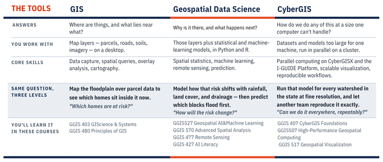
GIS is the toolset. Geospatial data science is the set of methods applied on top of it. CyberGIS is the computing infrastructure that lets both run at a scale a desktop can’t reach.
GIS: The tools for mapping and analyzing location data. It is the software, hardware, data, and methods used to capture, store, and analyze location- based information. GIS works in layers — parcels, roads, soils, sensors — so you can see how what’s there relates to where it is.
–Typical tools: desktop GIS software, spatial databases
–Runs on: a desktop or laptop
Geospatial Data Science: Is the methods that turn the data
into answers! It is mapping combined with statistics, machine learning, and large-scale computing. It sits in the middle where the fields meet: geospatial science, statistics, and computational science. Use it to find patterns, model how a system behaves, and predict what comes next. Every result is tied to a place, so you can compare across geographies to see what is connected.
–Typical tools: Python and R with spatial and machine-learning libraries
–Runs on: a workstation or the cloud
CyberGIS: The computing power to work at massive scale! CyberGIS joins geographic information science with advanced cyberinfrastructure and high-performance computing (HPC). It handles datasets and models far beyond what desktop software can hold — continental extent, fine resolution, hours instead of weeks.
–Typical tools: Python and R on HPC clusters, CyberGISX, I-GUIDE Platform
–Runs on: the cloud, a cluster, or a supercomputer
Learn more about our online program and how GIS, geospatial data science and cyberGIS are interconnected by downloading our quick info sheet HERE.